Introduction:
What? : The Muir Woods National Monument is one of the best places in California to see an old-growth coastal redwood forest.
Its proximity to San Francisco contributes to its
popularity, especially during weekends.
Where? : located on
Mount Tamalpais near the Pacific coast, in southwestern Marin County, 12 miles north
of San Francisco (20 minute drive from Golden Gate Bridge).
Google Map Link
When? : Year round, do
expect mist and fog and relatively colder temperatures during summer. Winter is
excellent time to visit the park, rainy day and fog add to the park atmosphere
and as a rain side-effect you may have fewer other visitors.
Due note 1: Reservations
are required for all vehicles ($8.50 per vehicle). An entrance fee of $15.00
per person is charged in order to gain park entry.
Please ensure
you have a printout or downloaded copy of your parking voucher before arriving.
Yearly National Park permit will save you the park entrance fee.
Due note 2: Marin Transit operates a shuttle on all weekends and holidays providing service to Muir Woods from Sausalito, Marin City, or Mill Valley ($3.25 per person)
Parking and Shuttle reservation
link:
https://gomuirwoods.com/
Due note 3: The Park is
open from 8:00 am and closes at sunset.
Due note 4: There are no
camping or lodging facilities in Muir Woods. There are camping options in the
adjacent Mount Tamalpais State Park.
There is a coffee at the souvenir shop inside the park.
Due note 5: The Park sees
up to 6000 visitors per day during peak times (weekends and holidays), you will
not be alone here and you should expect a crowdy experience.
Due note 6: Muir Woods National Monument is surrounded by Mount Tamalpais State Park.
Many trails to
and from Muir Woods connect with the State Park trails. These trails are usually
longer, narrow, unpaved, and often steep going up the mountain.
Link to my Blog covering Mount Tamalpais
Due note 7: To avoid the mandatory
parking reservation system or park fees you can park at Mount Tamalpais SP or
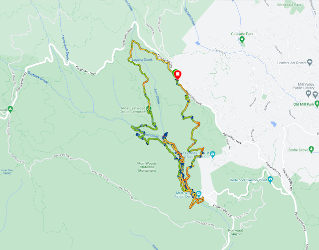
along Panoramic Highway and hike down to the park. Because I'm more into long hikes I usually start my hike up along the road and hike down to the park (see map below).
My thoughts:
The redwood forest in this grove is beautiful, probably the best location to see the redwoods near San Francisco. You can enjoy the easy hike and admire the trees.
My main "problem" is with the crowd, it is packed with other visitors, many are coming with shuttles and organized trips, definitely not an intimate nature experience.
Probably I need to come late at the afternoon on a rainy weekday to to have
better “nature” experience.
The
Muir Woods National Monument is an old growth coast redwood (Sequoia sempervirens) forests, one
of a few such stands remaining in the San Francisco Bay Area.
Due to its
proximity to the Pacific Ocean, the forest is regularly shrouded in a coastal
marine layer fog, that also vital for the growth of the redwoods as they use
moisture from the fog during drought seasons.
Coast redwoods are the tallest living things on Earth. The tallest reaches 379 feet above the forest floor of Redwood National Park at North California.
In Muir Woods, the tallest is over 258 feet.
Most of the mature redwoods here are 500 to 800 years old; some may be
over 1,000 years old.
By the early 1900s, people had cut most of California’s coastline redwoods.
This canyon, though, was never logged because its owners had protected it. In 1908, William and Elizabeth Kent donated this small old-growth redwood forest to the public.
Lower canyon and slops hiking option:
Enjoy a walk on the paved Redwood Creek Trail (also called Main Trail).
You can choose a short (1/2 hour), medium, or long loops (1 1/2 hour loop).
The trails in Muir Woods main canyon and redwood grove are asphalt or boardwalk and they are good for stroller and wheelchairs.
Trails on the canyon walls are dirt, narrow, steep, and rutted with tree roots.
This is an easy walk and you can create a loop trail crossing the creek on one of the 4 bridges crossing it to the trails on the other side.
Other trails go deep into Muir Woods
and Mount Tamalpais State Park.
All trails are well marked and are not difficult.
See my latest hike map:
www:
https://www.nps.gov/muwo/index.htm
https://www.parksconservancy.org/parks/muir-woods-national-monument
Map:
https://www.nps.gov/goga/planyourvisit/upload/map-muwo-trail-2019-small.pdf
https://www.nps.gov/goga/planyourvisit/upload/MUWO_171005_ParkChanges_HFCreplies_sm.pdf
Additional Pictures:
Additional Pictures from my Dec. 2022 visit
Additional Pictures from my Dec. 2022 visit


Comments
Post a Comment