
Introduction:
What? :
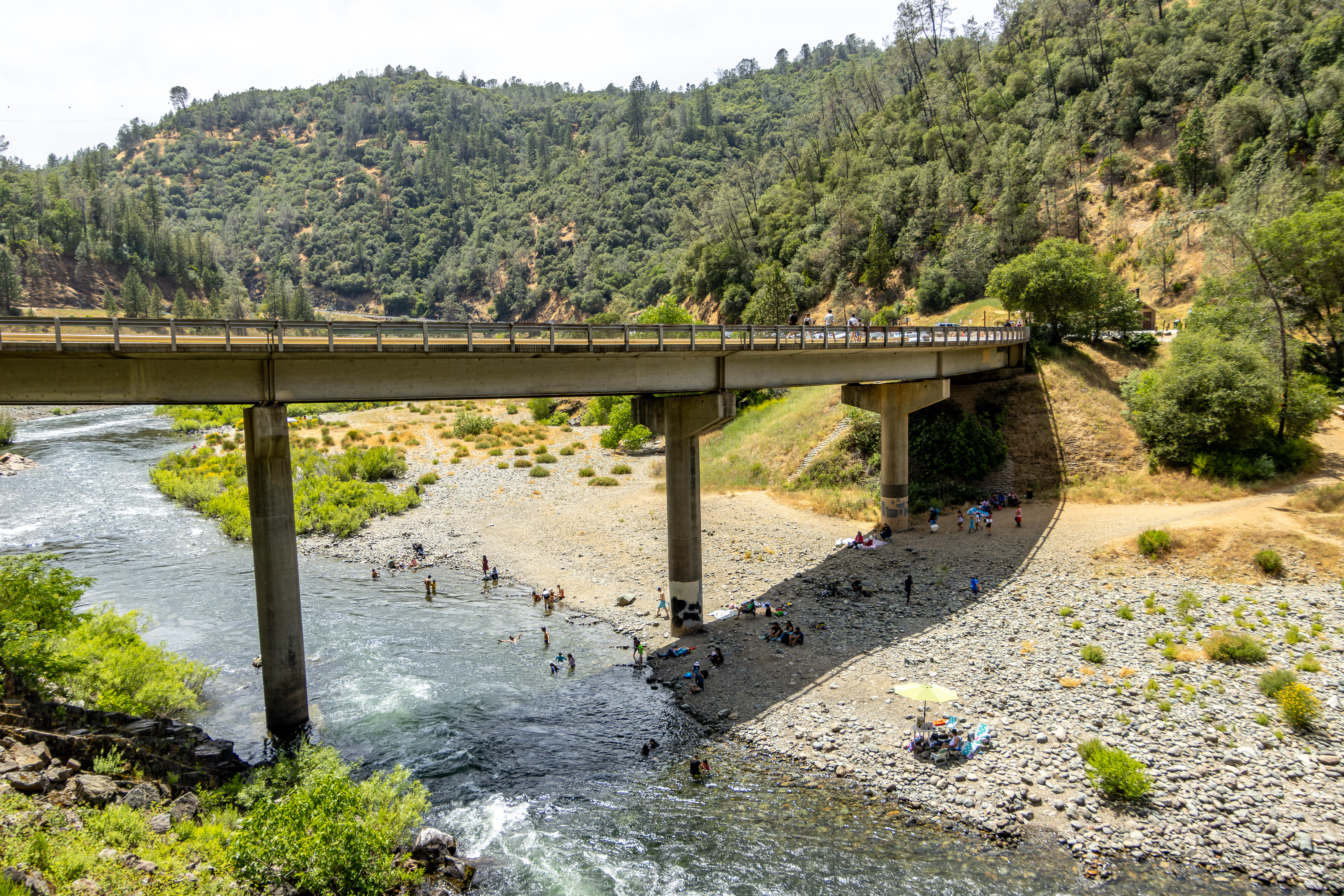
The hike from Auburn
State Park Kiosk located on the Old Foresthill Rd to Lake Clementine Dam follow
along the North Fork of the American River for 2.3 miles. This relatively flat
out and back 4.5 miles round trip hike (Elevation gain 785 feet), which follow
the river provide many river swimming locations as well taking you under the
tallest bridge in California, the Foresthill Bridge.
The Dam viewing
and the overwater flow is impressive.
During hot
summer days you can also spend here time enjoying the American River cold
refreshing water.


Where? :
Trailhead location:
137 Old Foresthill Rd, Auburn, CA 95603
Nearby there is
a small Auburn State Park Kiosk where you can pay for parking and get up to
date information from the park ranger, if the Park Kiosk is open.
Google Map Link


When? :
The park is
open year-round.
Summer
temperatures here average from high 80s to mid-90s, and winters are wet, with
highs in the mid-50s and lows in 30s and low-40s.

Due note 1:
You need to pay
$10 to park your car here, even on the side of the road, since it is a state
park.
There is a
self-pay kiosk by most parking areas.

Due note 2:
At summer
months it can be hot during mid-day, bring plenty of water with you.
There is no
potable water in the park.
Due note 3:
Although for
most part of the trail it is on a wide good dirt road there are few narrow sections,
and it is not a stroller friendly.
Due note 4:
Look for road
and forest condition in the park website (https://www.parks.ca.gov/?page_id=502).
Upper Lake
Clementine - Reservation is required on Weekends
Due note 5:
Pets must be
under control and on a leash.
Due note 6:
This is a very
crowded area, especially during hot summer weekends. At this section of the joining
of the two American rivers there are many people that are coming to enjoy the
cold water at hot summer weekend.

My thoughts:
We visit here
on a summer mid-day, and it was hot to walk but not too terrible.
We put
sunscreen and took enough water with us. The hike itself is not challenging too
much and it was relaxing to walk along the river and cross under the impressively
tall Foresthill Bridge.
The view of the
dam and the water running over it is impressive, the falling water create a spray.
You can cross the rail and walk down the steep rocky section to see the dam
from below.

The Visit:
Information about Auburn SRA:
Auburn State
Recreation Area (Auburn SRA) covers 40-miles of the North and Middle Forks of
the American river, the area is now a natural area offering a wide variety of
recreation opportunities to over 900,000 visitors a year.
The main access is from Auburn, either on Highway 49 or Foresthill Road.
Major
recreational uses include hiking, river access, boating, fishing, camping,
mountain biking, Whitewater recreation is also very popular on both forks of
the river.
Auburn SRA is made up of mainly federal lands, but it is manage by California
State Parks administers.

The Hike:
Generally
considered a moderately route, it takes two hours to complete. This is a very
popular area for outdoor activities, so you'll likely encounter other people
while hiking here.

From the small
park ranger station, you will be heading along the roadside, cross the bridge over
the river, then you will see on your left the gated dirt road, this is the
trail start.
You will follow
this wide dirt road path for the next 2 miles.

The trail overlooking
the river and along the hike you can find many places where side trails are leading
to the river below.
When it is hot day,
it is probably better to get some river swimming on your way back.

This section is
relatively open and unshaded so at mid-day it can be hot. Here you will get a
nice view on the tall Foresthill Bridge.
The tall,
massive bridge towering 730 feet above you, crossing the canyon over two large
concrete pillars on each side of the river.
Near the bridge
the trail get narrow for a short section, but it widen again into a good dirt
road.


From here the
trail start with a moderate uphill climb, here there are a lot more trees
covering the trail.

After about
reaching the 2 miles mark you will pass another close gate and reach the park
road. Here you need to turn left heading down to the direction of the lake and
the dam.

In this section
there is no trail, and you need to walk on the road, stay alert from incoming
cars in both directions.
After very
short but steep downhill walk along the road you will see a small clearly
marked trail leading to the left.
After a very
short hike you will reach the end of the trail, here from the viewing platform you
will be able to see the dam from above and Lake Clementine behind it.


There is un-official
trail that can lead to the lower section and the base of the dam.

The dam
rises 155 feet above the rocky creek foundation and has a crest
elevation of 718 feet. The reservoir behind it cover a surface area of 280
acres.
When we visit
here (June 2024) it was very impressive to see the running water over the tall arched
concrete dam.
The viewing
location is shaded, and it is a great spot to take a break drink and have a
snack.
From here you
will head back the way you came in. starting with a short and steep paved road
and then turn right into the dirt road trail, downhill the whole way along the
river and under the bridge back to your starting point.
Overall, this 4.5-mile
hike to the dam and back will take you about two hours to complete, you can
extend your visit by swimming in the river or having another nearby hike.
www:
https://www.parks.ca.gov/?page_id=502
Map:
https://www.parks.ca.gov/pages/502/files/AuburnSRAFinalWebLayout2016.pdf
https://www.parks.ca.gov/pages/502/files/ASRA_Brochure_Map_UPDATED_2021.pdf
Additional Pictures:


Comments
Post a Comment