Introduction:
What? :
Utah state
Route 12 Scenic Byway is a 123-mile-long state highway in Garfield County and
Wayne County. The road starting at it southwest end at highway 89 near the
small town of Panguitch, from here its travers all the way to it northeast end at
highway 24 near the town Torrey.
This southern
Utah's road pass by 2 National Park, Bryace Canyon at the south side and
Capitol Reef at the north side. It is the gateway to the large Grand
Staircase-Escalante National Monument area, State Parks, small rural pioneer
origin communities, large open Plateau, Dixie National Forest, and the scenic high
Escalante Mountains range.
There are so
many things to see and visit along this drive but the drive itself is tourist
destinations unto themselves, this is why it was also designated an
All-American Road.
The drive passes
through vast landscape, countless panoramic viewing points, twisting canyons,
red rock towers, high mountains with pine and maple forests and small pioneer
towns.
Most tourists
that are visiting southern Utah want to visit the “Big Fife” National Parks:
Zion, Bryce, Capitol Reef, Arches and Canyonland.
You can visit many
other nature wonders, like: Natural Bridges, Monument Vally, Antelope Canyon, Horseshoe
Bend, and the Grand Canyon National Park (south and north rim).
Highway 12 is one
of the most beautiful sections of this “Grand Park Road-Trip Loop”.
The 123-mile-long
road can be completed in about three hours if you're just driving here, but in
my mind, this will be a mistake to plan for that.
Between the two
national parks (Brice Canyon, Capitol Reef), several state parks (Kodachrome,
Escalante Petrified Forest, Anasazi Museum) and the vast open Escalante Monument,
and interesting geological area, you can easily spend one week along this
road.
For many
outdoor recreations enthusiastic this road can be the gateway to many weeks of outdoor
recreation options like day and long multi-day hiking, canyoneering, dirt road
driving and overloading into remote areas, and many more.
In the below
blog I tried to create a long list of destinations, parks, and interest point,
along the drive. My road description is ordered south to north, but you can
drive it also from northeast to southwest, depending on your overall trip
planning.
I will provide
here only short description.
If I have such,
I will also provide links to dedicated blogs.
Where? :
Utah state
Route 12 Scenic Road starting at it southwest end at highway 89 near the small town
of Panguitch, all the way to it northeast end at highway 24 near the town Torrey.
When? :
The road is
open year-round, and overall, in a very good driving condition.
It is important to understand that after winter snowstorms, some sections of the road might be impassible to cross until plowed, this is especially happening at the Boulder Mountain high elevation stretch during the winter months (Bolder to Torrey section of the road).
Not sure if there is night plow activity on this road section.
Winter has cold
temperatures with snowstorms
The road elevation
ranges from 4,000 to 9,600 (3,000 m) feet above sea level so also temperature
and local climate can change as you drive along the road sections or during the
day hours.
Summer days are
hot, with mid-day temperature are usually above 90f, as you climb to higher
elevations temperatures are coolers.
Fall season
bring with it Aspen trees fall colors (yellow and orange) at the high elevation
of Bolder Mountains section.
Accommodations and Food:
There are many
options for accommodation along the drive.
The main towns along
the road are Panguitch, Bryce Canyon City, Tropic, Escalante and Torrey.
In the
southwest section of the road this is mainly near Bryce Canyon. The local towns
of Panguitch, Hatch on highway 89 and Bryce Canyon City, Tropic and Cannonville
on highway 12.
In the center
section this most accommodation options are in the town of Escalante.
At the north
section of the road the main town that has hotels/motels is Torrey.
There are
countless small and unique glamping, and camping sites along the road, mainly around
the towns.
Along the road
there are many dining options, near hotels and at the small towns.
Due note 1:
This is 130
miles long road and there are gas stations along the road at all towns including
Escalante and Bolder.
Due note 2:
Cell phones do
not work along many long sections, due to the rugged mountains and canyons terrain
and remoteness from nearby towns.
Due note 3:
Highway 12 is a
relatively a new state road, the completion of a year-round road from Escalante
to Boulder to car traffic was in 1939. The northern portion of Highway 12 over
Boulder Mountain (connecting Bolder to Grover and Torrey) was paved only in
1985.
Overall, when
it is not snowed/ice driving conditions are good but do expect sharp curves and
no paved shoulder.
Places to Visit and See Along the Road:
High level description:
Along this road
you will pass through several varied landscape areas and unique places of the
Colorado Plateau.
At the south it
will be the Red Canyon and Bryce Canyon National Park area, from there you will
drive west into the Grand Staircase-Escalante National Monument arid landscape
and farmlands in the valleys near the road.
Map of Grand Staircase-Escalante National Monument:
Driving north
of Escalante all the way to Bolder the road will take you into the colored desert
and canyons of the Escalante River basin.
North of the of
the isolated small-town of Boulder the landscape will change as the road climb
up to the high Bolder Mountains.
Here the high mountains
covered with pine and aspen trees, from the roadside viewing points you can
enjoy the amazing vistas to the east.
From it high
point (above 9,000ft) the road descend again, passing through Grover community.
Soon after you will reach the town of Torrey and highway 24, here you are back again
in the south Utah desert landscape and can visit the nearby Capitol Reef
National Park.
In the below blog I tried to create
a long list of destinations, parks, and interest point, along the drive.
My road description is ordered
southwest to northeast, but you can drive it also from northeast to southwest,
depending on your overall trip planning.
I will provide here only a short
description.
If I have such, I will also provide
links to dedicated blogs.
(miles distance from the junction
with highway 89 near Panguitch, Utah)
Red Canyon (3.4 miles)
The Red Canyon
Visitor Center is located just off Highway 12, 3.4 miles east of highway 89.
Here you can
find a small visitor center, a campground and many hiking and HOV trails options
exploring the spectacular red sandstone spires and formations.
Here the road
pass through two small tunnels that resemble rock arches.
Bryce Canyon National Park (18
miles)
Bryce Canyon
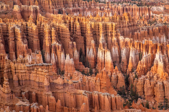
National Park is one of the most famous parks in the west, it is known for re-orange-crimson-colored
hoodoos formation located in large natural amphitheater underneath the high flat
rim.
The park has many
overlook viewing points, like: Sunrise Point, Sunset Point, Inspiration Point
and Bryce Point. You have many different hikes in all difficulties level to
explore this amazing place, preferred viewing time is around sunrise and sunset.
Link to my blog about this location
Kodachrome Basin State Park (34
miles)
To visit Kodachrome
Basin State Park, you need to drive 24 miles on highway 12 and at the small town
of Cannonville turn into a side road that leads to the park, this will be additional
12 mile of driving.
The small state
park scenery is unique, it dominated by many monolithic stone spires called
sedimentary pipes, surrounded by the red rock formation. Although its
outstanding scenery it is not as famous and usually less crowded, probably
because it is not located right on highway 12 and the proximity to Bryce
Canyon. It is a great place to camp and hike the park relatively short trails.
From the park
start Cottonwood Canyon Road that will take you deep into the Escalante desert,
the road is a destination by itself.
Link to my blog about this location
Cottonwood Canyon Rd. (34 miles)
Cottonwood
Canyon Road is a scenic 46-mile dirt road that traverses Cottonwood Canyon, passing
through Grand Staircase Escalante National Monument’s rugged landscape. The dirt
road begins in Kodachrome Basin State Park, 12 miles off Utah State Route 12,
continues southward through the desert and Paria River basin, and eventually
connects to U.S. Route 89. Usually the road is in good conditions but some places
may require AWD, when wet it is impossible to drive on.
Although not
very long you should plan at least half a day for exploring some of Cottonwood
Canyon’s narrow canyons (Cottonwood Narrows, Lower Hackberry Canyon, Paria Box),
natural arches (Grosvenor Arch), and enjoy the impressive views of the Navajo
sandstone cliffs and formations.
Link to my blog about this location
Escalante, Utah (60 miles)
Escalante is a
city in central Garfield County, Utah, United States, located along Utah Scenic
Byway 12 in the south-central part of the state. Originally this was a small
ranching town nestled in the large valley of upper Escalante River. Today with
only 850 residents, it is still the largest town for 70 miles in all
directions. Over the years and the gain in popularity of this remote and unique
area among outdoor antispastic the town became to be a tourist center of this
area.
It keeps the unique
charm of small farmers ragged town with many of tourist services, like visitor centers,
outdoor shops, hotels, cafes and diners, gas station, and more…
The town recommended
as an access point and a basecamp to some of the most beautiful desert areas of
Southern Utah. There are many hikes and canyons explorations along Hole in the
Rock Rd., or along the remote section of Hell's Backbone Rd., or the vast
canyon playground along the isolated 70-miles-long of Escalante River.
I visit here
several times and I’m sure I will visit here again, there is so much thing to
do and new places to explore.
Few of the blogs
on locations near here:
Escalante Interagency Visitor
Center (60 miles)
This is the
visitor center of the Grand Staircase–Escalante National Monument. The huge
monument area spans a spectacular stretch of nearly 2 million acres across the
Colorado Plateau in southern Utah. Here you can do a short hike or spend weeks
of backpack trips, go canyoneering in the deep slot canyons, drive long or multi-days
of overlanding trips. The monument’s remote and rugged nature, out of the main between
tourist path, makes it a great way to experience the wonders of southern Utah.
Along most of your
highway 12 drive you will be near or in the monument area.
Summer hours
will be from 8:30 a.m. to 4 p.m., six days a week (closed Wednesday) beginning
Friday, Mar. 1.
Escalante Petrified Forest State
Park (60 miles)
Just outside of
the town of Escalante sits Escalante Petrified Forest State Park. This unique small
park has hiking trails and places to see a variety of petrified wood structures
and other beautiful landscapes. Wide Hollow Reservoir is also at this location,
along with some campsites.
Escalante Heritage Center (60
miles)
Today, the
Escalante Hole in the Rock Heritage Center stands as a testament to that
determined pioneer spirit. The nine-acre heritage site sits along Scenic Byway
12 near the entrance to the Hole in the Rock Road, and at the north end of the
town of Escalante. The Escalante Heritage (Hole-in-the-Rock) Center consists of
an information plaza of kiosks talking about the Hole-in-the-Rock expedition
and the settling of Escalante. This center is created to preserve, educate, and
inspire while connecting with the place and the story.
Hole in the Rock Rd. Wayside (65
miles)
Just off
Highway 12 4 miles northeast of Escalante, the historic pioneers Hole in the
Rock Road offers 55 miles of off-roading drive deep into the desert.
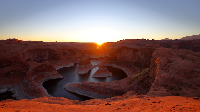
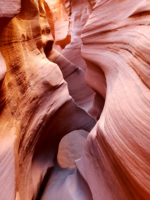
The road is usually well maintained and can be done by AWD. There is used as a gateway to amazing hikes and trails that leads deep into the local canyons and unique rock formations. Highlights of trails along this route can be Peek-a-Boo, Spooky, and Zebra slot canyons, Devil’s Garden rock formation, long and strenuous hikes into Escalante River Canyon branches, and one of the most beautiful places I ever visit, Reflection Canyon in a remote section of Lake Powell.
Hell's Backbone Rd. (60 miles)
The Hells
Backbone Road, 38-mile-long drive, is a winding route that follows ridges and
mountain crossing the ragged upper Escalante River between the towns of Escalante
to Bolder.
The road is
gravel, graded occasionally, and suitable for family cars during dry weather. It
was built by CCC (Civilian Conservation Corps) workers during the Great
Depression era.
Head of the Rocks Overlook (70
miles)
Head of the
Rocks Overlook is located along Scenic Byway 12, over viewing Grand
Staircase-Escalante National Monument. The overlook affords expansive views out
across the ragged Escalante Canyons and colorful slickrock stretches almost as
far as the eye can see.
One of the most
incredible parts of this viewpoint is seeing below you Highway 12 as it winds
through and crosses the vast slickrock terrain.
Link to my blog that shows many pictures from this viewing point.
Escalante River Trailhead (74
miles)
Here at the
heart of highway 12, when it is crossing the canyon of the Escalante River you
can find several amazing hiking options. You can see here the 100 hands wall
paining and unique petroglyphs, hike up the Escalante River Canyon to see natural
bridge, arc and old pueblo dwelling or hike down the river to Phipps Arch. There
are other day and multi-day hiking options that start here.
Links to relevant
blogs:
Lower Calf Creek Falls (76 miles)
Right off the
road, at a place called Calf Creek Campground is the beginning of a trailhead
that leads along the impressive Calff Creek canyon to Lower Calf Creek Falls. This
area is managed by the state although not officially declared as a state park.
The Hogback (79 miles)
At one point
along Scenic Byway 12, between the communities of Boulder and Escalante, is a
unique stretch of road called The Hogback. Here the road climb up from the
canyon of the Escalante River and it runs along the top of a steep narrow ridge
line. There are drops from both side of the narrow ridge, right off the road
and the ragged landscape view in both sides is impressive.
There are
several offroad viewing point so do not block the highway when you want to stop
and enjoy the view.
Boulder, Utah (87 miles)
Situated south
of the Boulder Mountain, nestled between (and within) land of the BLM, Forest
Service, and Grand Staircase-Escalante National Monument, you can find the
small town of Boulder. It is small, isolated, remote, and spectacular old
pioneer farmers town. The first white settlement began in 1889, with Boulder
incorporated as a town in 1958. As of the 2020 census, the town population was
227.
Boulder claims
to be the last community in the continental United States to receive its mail
by mule train. Completion of a road in 1939 opened Boulder to car traffic from Escalante.
The northern portion of Highway 12 over Boulder Mountain was only paved in
1985.
You can find
here few places to eat and night accommodation as well as Anasazi State Park
Museum and the start of the Burr Trail Rd. that leads deep east all the way to the
south remote tip of Capitol Reef Nation Park.
Burr Trail Rd. (87 miles)
Located just
outside the northeast region of Glen Canyon National Recreation Area in
Bullfrog, the 67-mile-long Burr Trail offers excitement for the adventurous
explorer. It crosses Grand Staircase Escalante National Monument, Capitol Reef
National Park, and Glen Canyon National Recreation Area and provide views of
features like the Henry Mountains, Waterpocket Fold, the red Circle Cliffs,
Long Canyon, and Pedestal Alley as long as many hiking options along the road.
The Burr Trail
Road is most easily accessed from Boulder, Utah, here the road is still paved
for the first 30 miles.














Comments
Post a Comment