Introduction:
What? :
Angels Landing
is probably one of the most popular hikes in Zion National Park, The Narrows
hike is the second one.
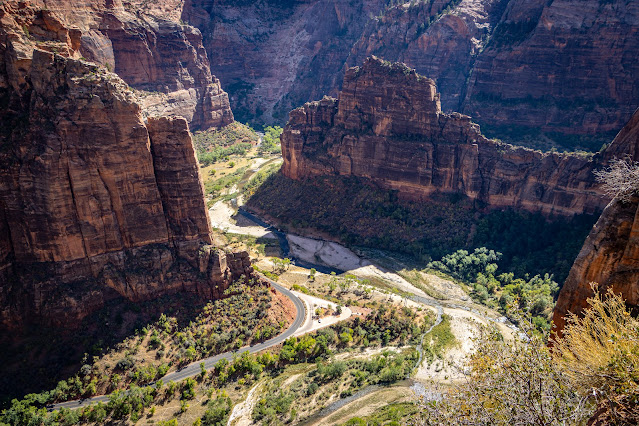
The view from
the top of Angels Landing is spectacular, you see the Zion canyon and Virgin
River below you as well as the colorful impressive mountain domes around you.
Hiking the 5.4
miles round trip trail and climbing to this 1,500-foot-tall rock to Angel
Landing is a must adventure hike for every serios hiker. Plan for few hours (~3
hours) if you are in a good fit or a half a day hike for the rest of us. Expect
delays on the chine section.
If you are
planning only to hike to Scout Lookout this will be 4.6-mile
round trip with 1,000 ft of elevation gain.
Related Blogs:
- South Utah - Parks Grand Circle
- Utah Southwest - For The Advance Travelers
- Zion National Park – Plan Your 1-5 Days Visit
- Zion National Park – The Narrows Hike
- Zion National Park – Viewpoint on Walter’s Wiggles Engel Landing Hike
- Zion National Park – Emerald Pool Hike
- Zion National Park – Drive Through the Park Road
- Zion National Park – Canyon Overlook
- Zion National Park – Kolob Area
- Zion National Park – Kolob Area, Middle Fork Taylor Creek Trail
- Zion National Park – Kolob Area, Kolob Arch and LaVerkin Creek Wilderness Hike
- Zion National Park – Kolob Terrace Area
- Zion National Park – Kolob Terrace, Northgate Peaks Trail
- Zion National Park – Kolob Terrace, Lava Point and Kolob Reservoir
- Grafton Ghost Town (located near Zion National Park)
- Zion National Park – Smithsonian Butte Road and Viewpoints
The trail got
it famous reputation from the climb along the narrow and steep knife ridge line
leading to the viewpoint. In some sections you will need to use the chains and
do some rock scrambling to progress, this can be intimidating both on your way
up or when climbing down.
In some
sections the narrow trail is only few feet wide where straight cliffs on both
sides, falling here is sure death.
This is
definitely one of the most famous hikes in all of the USA national parks and a great
hike to put on your bucket list.
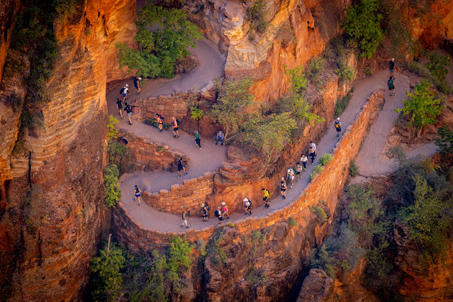
The trail
starting near the river at it lower point it climb along the canon walls into
crack in the rock and then with another series of steep 12 switchback to Scout
Lookout, this will be after 1.7 miles and 1,100 ft elevation gain climbing from
the starting point. From there it is another steep climb in the narrow cliff
section of the hike to the top of Angels Landing, another 0.4 mile and 500 ft
elevation gain.
Plan for few
hours to hike to Scout Lookout and half a day to the top of Angels Landing, the
last section, although not long is very slow progressing. Even with the permit
system mid-day there are many people climbing up and down at the narrow section
and using the chains for both directions. Plan for a lot of waits along this
hike sections.
Angels Landing Permit:
In order to limit the number of people on the trail at its steep cliff chains section the National Park Service now requires hikers to have a permit.
This is needed year
round.
If you plan to
hike pass Scout Lookout all the way to Angels Landing highest point, going over
the narrow cliff section using the chains, you must have a permit in advance!
Rangers are checking
valid permit before the climb.
Prior your
arriving into the park download or print your permit because there is no cell
reception in the park.
Permits are
awarded by lottery system (for up to six people per permit request), you can
have seasonally permit or a day before your planned hike. It costs $6 to enter
an application and if you are one of the lucky lottery winners, you will pay $3
per person.
For dates of
the seasonal lotteries, how the day-before lottery works, and the link to enter
the lottery, visit the park website:
https://www.nps.gov/zion/planyourvisit/permitsandreservations.htm
Travel Time and Milage to Zion
Visitor Center:
Salt Lake City,
UT: 4 hours 23 minutes, 308 miles
Las Vegas, NV:
2 hours 39 minutes, 160 miles
St Gorge, UT: 1
hour, 42 miles
Bryce Canyon: 1
hour and 50 minutes, 82 miles
Kanab, UT: 1
hour, 41 miles
Page, AZ: 2
hours 20 minutes, 116 miles
Where is the trailhead and Zion Shuttle
System:
The trailhead
is located along the road following the park canyon, Virgin River, at The
Grotto, stop #6 on the Zion Shuttle.
This ride from
the visitor center to the trailhead is approximately 30 minutes long.
For most of the
year month you can’t drive up the road that takes you the trailhead and you
need to use the free shuttle service that run in the park or by riding bike up
the road.
Check at the
park website for exact shuttle operation dates and schedule.
You will need
to park at the Visitor Center, right near the town of Springdale.
If the visitor
center parking lot is full, usually happen at 9am at spring, summer and fall
months, you can park at the nearby town (paid parking) and use the town shuttle
to get to the visitor center or walk over.
In busy months
you can have a waiting line of 30-90 minutes long for getting the shuttle, come
as early as you can but expect many others to do exactly the same.
The potential
for no available parking near the visitor center and the wait for shuttle must
be part of your visit schedule planning.
This shuttle
system is hop-on hop-off so you can use it for any stop along it route.
When hiking at
the afternoon, know when the last shuttle schedule and plan to be in the
shuttle station 30 minutes prior to last ride.
If you miss the
last shuttle you will need to walk to the lodge and see if you can get a
private transportation from there.
Google Map Link
For a Beautiful Nature Prints - Visit my Etsy Store
When? :
Zion National
Park is open year-round.
Spring and fall
are the preferred time to visit here.
In summer
temperatures are about 100f during mid-day so plan accordingly.
Try to start
your hike early in the morning or late afternoon, evaluate the trail climbing
difficulty and your hiking ability, bring enough water with you, snacks and
light food, as well use sunscreen, wear hat, sunglasses and long sleeves.
Summer also is
the most crowded time of the years, Zion get several hundreds of thousands of
visitors every month, this create a lot of loads on the shuttle system and
trail congestion and overcrowded locations.
One of the many
benefits of hiking in Zion National Park is that its canyon elevation is not
high (4,000-6,000ft), and most trails are doable year-round, thanks to the
typically mild weather.
Winter months
are cold, the night temperatures can be below freezing, and the days are around
60f. You might find snow and ice on trails.
Due note 1:
Zion National
Park enter pass costs $35 per vehicle. This pass will cover your visits to Zion
for one week.
If you want you
can buy a year pass for all US National Parks, that will cost you $80.
No need to pay
or reserve the free park shuttle.
You do not need
a permit to hike to Scout Lookout.
Due note 2:
No matter until
where you go this hike start with a lot of uphill climbs, plan accordingly.
Due note 3:
Tourist coming
to Utah’s most popular national park reach around 3.5 million visitor per year.
The popular trail
can have thousands of hikers per day, many are hiking only to Scout Lookout. Summer
months are the busiest.
Many try to
start their hike as early in the morning they can, depending on shuttle service
start time (check park website).
Mid-day is very
busy time even offseason.
Due note 4:
For all the
length up to Scout Lookout the trail is fully paved with local send concreate,
so it is in a great condition.
Due note 5:
At the at The
Grotto starting point you can find restrooms and water.
Due note 6:
Pets are not
permitted on any trail.
Due note 7:
The trail is
exposed to the sun so bring water with you, use sunscreen, hat and sunglasses.
Due note 8:
During the winter
after snow storm the trail could be treacherous with possible ice and snow
patches on the trail. Spikes and tracking pools are good addition.
Due note 9:
When you are
back at the shuttle you can take the bus going to the narrows direction or the
one taking back to the visitor center direction.
Due note 8:
Check the
seasonal shuttle schedule before you leave to make sure you do not miss the
last shuttle.
Due note 9:
If you have the
time and energy the Emerald Pools are a nice follow-up hike after finishing Angels
Landing hike, and it start from the same trailhead.
Due note 10:
Inside the park
along the canyon road the nearest snack bar, restaurant and souvenir store is
located at Zion Lodge (shuttle stop #5).
No service or
other stores/food available on Zion-Mt. Carmel Road (highway 9).


Comments
Post a Comment