Introduction:
What? :
Owl Canyon Hike
is 3.4-mile-long loop trail with 250 ft elevation gain.
This loop route
passes two desert washes that created when the crosses the relatively soft conglomerate
rock short slot canyons.
You will hike
up Owl Canyon, that is longer and more impressive, connect to the bike road and
hike down the second wash that is shorter but has a nice 10ft waterfall.
From the second
wash you will be reconnect to the direction of the parking lot or you can hike
and explore Las Vegas Wash.

This easy to moderate
hike will take you about 2-3 hours, depending on if you will explore the Las
Vegas Wash area.
This is a loop
hike so you can do it in each direction, I did it clockwise.
Another hiking option
is to walk only in the Owl Canyon, this is the longer and more impressive of
the two canyons. Once you reach the end (the tunnel under the bike road) you
simply turn around and hike back, this will be about 2 miles hike.

Where? :
Lake Mead NRA is
located east of Las Vegas Valley.
From Las Vegas
drive east on highway 564 (E Lake Mead Pkwy). Pass the park entrance fee
station and keep driving straight at the first road junction.
From the
junction drive 4.1 miles and you will see a road leading to the left too few
parking lots.

Take the first entrance to the left, here you will find the
trailhead.
If you are
coming from the direction of Hover Dam and Boulder city, get into Lake Mead NRA,
Lakeshore Rd and pass the park entrance, from here you need to drive north for 8.4
miles until you see the turn right to the parking lots.
When? :
The best times
to visit this trail are October through April.
For the hot
summer months that has extreme high temperatures, mid-day may be too hot to
enjoy.
The temperatures
during the long summer months are extremely hot, easily reaching over 115f and
even early morning temperatures are above 80f.

Due note 1:
Lake Mead
National Recreation Area is open 24 hours a day, 365 days a year.
Admission fees
for Lake Mead National Recreation Area are $25 for vehicles. These passes are
good for up to seven days. Campgrounds are $20 per night. You can use here the
National Park Year Permit.
Only electronic
card payments are now accepted for entrance, lake use, and campground fees.
Entrance stations will continue to sell passes but will no longer accept cash
for payment.
Due note 2:
There are shade
and picnic table at the parking lot.
There are
restrooms but no source for water filling.
You have cell
reception in most of the area near Las Vegas.
Due note 3:
During summer
month it is extremely hot and although this is not a long or challenging hike
it is not recommended mid-day, come as early in the morning as you can or late
at the afternoon.
Due note 4:
Dogs are welcome
to Lake Mead NRA but must be on a leash.
Due note 5:
Overnight
camping is not permitted.
Due note 6:
Bring enough water
with you for half day hiking.
The trail is
exposed to the sun and do not have any shad, except in the narrow canyon.
Due note 7:
As always in
the desert I recommend long sleeves shirt, heat, sunblock, and sunglasses.
Due note 9:
Because you are
near Arizona the time zone may change in your phone, be aware of that when
you are hiking, make sure you have enough sunlight for the long hike back out to
your car.
Due note 10:
This is a very
popular area for hiking, so you'll likely encounter other people while
exploring the area.
Due note 11:
I did not see
any owl during my visit (Dec. 2024), I think they are nesting early spring….
Due note 12:
I see this hike
as family friendly where kids, as adults, will enjoy the canyon section of the hike.
There almost no
climbing, most of the walk is in riverbed. Yong kids might need some help
overcoming the 10ft waterfall in the far canyon, so maybe it is better to do
the loop counterclockwise, so you climb the waterfall, which is simpler for
most.

My thoughts:
This is a fun
hike, not so long and no elevation gain, with interesting small canyon. When I
visit here during Dec. 2024 there were no owls, I will probably come back to
visit here when they can be found.
The trail
extension to the river section is fun and it is interesting to see the water
environment in the harsh desert.

The Hike:
This area was entirely
submerged beneath Lake Mead, Owl Canyon was exposed as lake water levels
dropped, in recent years the lake level are far away.

The hike start
at the parking lot, you can clearly see the trailhead signs on the left side.
From here the trail descending steeply to the dry riverbed below.
This short
steep section is unstable sand so walk slowly
The trail
crosses the dry bead, climb a small hill and start heading left into the large wash,
going upstream walking over loose river pebbles and sand.
Soon the wide
wash start to narrow, and you will see the canyon entrance.
This is not a
deep slot canyon; it curve it way in the riverbed gravel conglomerate rocks and
it walls are about 100-foot tall.
The canyon is
winding and twisting and, in some sections, it become relatively narrow where
the rocks almost closing on you from above.
In this section
of the canyon, you can find owl nesting.
This usually
happening during the early spring months.
The only evidence
for owl nesting I saw was the white bird-pop marking on the rocks below the
alcoves.

This narrow section
of the canyon is not so long, about quarter of a mile.

Keep walking up
the dry wash and after 0.7 mile from you hike starting point you will reach the
section where the road is passing above the canyon.
Here, two large
drainage metal tunnels are crossing underneath the road.

Keep walking and
after a short distance you will see another underneath road passing tunnel,
here the “old road” passes above.
Today this road
is a bike trail that span over 40 miles loop.
Cross
underneath the bike road, pass it to it far side, this time the tunnel is
smaller compared to the first one.
After crossing
the tunnel the wash open-up, keep walking and you will see the trail climbing up backward to the
road level, this will be on your right side.
This will be 1.1
mile from your hike starting point.
When you are
climbing back to the road you need to turn left (north).
Be careful from
bike riders when you are walking on the bike trail.
The bike trail
paved road passes few small washes and after 0.5 mile you will see a clear hiking
trail off the road heading to the right, getting into a large dry creek.
Take this trail
and get into the creek.

After a short
walk you will pass under to road, short after the creek get narrow and after a
turn to the right you will reach a small 10 feet tall dry waterfall.

Here you
need to climb down the waterfall, there are rock ledges and platforms to put
your feet when you are climbing down.

Keep hiking
down the creek and after a very short walk the canyon open-up into a large dry
riverbed. Soon after you will reach Shoreline Trail.
Here you have 2
options:
The first option
is to find Shoreline Trail heading to the right of the dry wash, this will be
the shorter way back to the parking lot and the “official” loop hike. On your
way you cross a high elevation before the trail start to head into the
direction of the trailhead.

You will pass 2 large red rock formations (“mini
mountains”) and get into the relatively wide Owl Canyon wash.
From here you
will climb back to the parking lot and the trailhead.
The second
option is to hike and explore the lower section of Las Vegas wash, you can find
Shoreline Trail leading to the left.
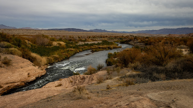
In this area
the Las Vegas wash passes through dense riverbank vegetation and marshes area.
The smell of
the semi-treated sewage water is notable but not so bad.

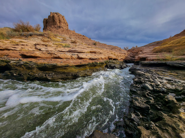
You can see
here some interesting red rock formations, here the wash has a short narrow “river
rapid” bending section, vegetation and water birds.

I did some
short exploration here before I start to head back to the direction of the trailhead.
I walked on Shoreline
Trail and reconnected with the “official” loop hike.
After additional
short walk I saw the parking lot on the hill and climb up.
With my extension
this was 4.95 miles long hike and it took me 2.5 hours.
Overall, this
is a fun hike passing through interesting narrow canyons.
Fun winter
activity.
Additional Pictures:


Comments
Post a Comment