Skip to main content
Red Rock Canyon – Turtlehead Mountain Hike
Introduction:
What? :
Located in the
heart of Red Rock Canyon Park, Turtlehead Mountain Hike is out-and-back 4.6-mile
with a total of 2,000 feet climb trail that led to the impressive cliff top
mountain with 360-degree view of the Red Rock Park area, the impressive
surrounding mountains and far away in the valley stunning views of Las Vegas
strip.
The hike is considered
a challenging route, and it takes an average of 3-4 hours to complete.
Warning:
This is a challenging
climb hike that requires some steep walking and slippery sections so you must
walk with awareness and be careful not to fall.
This is not the
trail for people with far of highest or instability or for young kids.

Where? :
The park is located
17 miles west of the Las Vegas Strip and city center, about 30 minutes’ drive.
You can take Charleston Boulevard/State Route 159 and drive west or use the 215
highway and exit at W Charleston Blvd and NV-159 W/Red Rock Canyon Rd. From
highway 215 drive for 5.9 mile and then you will see the park entrance on your
right.
The Calico
Tanks Trailhead is located at Sandstone Quarry Overlook Parking Lot, this will
be 3 miles up the scenic view one-way road.

When? :
The park is
open year-round, but the late fall and winter month are the recommended time to
visit here.
Temperatures
can average more than 100 degrees Fahrenheit during the summer months. If you
are planning to hike, try to come early in the morning. The best protection
against heat is drinking plenty of water and limiting exposure to the sun
during the hottest parts of the day.
The park
averages 294 days of sunshine per year.
Summer
afternoon monsoon rainstorm is expected, be aware of flash flood and lightning.
Winter mid-day
temperatures are the best for hiking, cold night around freezing and mid-day
around 50-60f with almost no rain at all.
Due note 1:
Entrance
Reservation:
To manage
visitor overcrowded and congestion, protect the nature and improve visitor
experience the access into the park visitor center and Scenic Loop Road is
controlled by an online reservation system.
This system is implemented
between November 3 through May 31.
The park road
is open starting 6am.
Between 8 a.m.
- 5 p.m. a Timed Entry Permits (+/- 30 min) is required per vehicle.
Timed entry
reservations can be made at Recreation.gov or by calling 877-444-6777.
Note: You can
still hike in Red Rock Canyon NCA without the need for reservations or paying
fees when hiking into the park from the nearby areas.
Note: Actually,
most of my visits and hike into the park started outside the park road, yes it
a lot longer hike but you can enjoy this area even if you do not have entrance
reservations.
Due note 2:
Daily Private
Vehicle Entry $20; America the Beautiful Annual Pass is accepted.
Visitor Center
is open daily 8 a.m. to 4:30 p.m.
Red Rock Canyon
Main Information Line: 702-515-5350
The Park Visitor
Center is located just after the entry kiosks at the start of the one-way,
Scenic Loop Road.
You can find gift
shop in the visitor center.
Due note 3:
Cell service is
limited, make your park reservation prior driving here. If you plan to hike
download your map.
At the visitor
center there is wifi.
Due note 4:
Pets are
welcome at Red Rock Canyon National Conservation Area. Pets are permitted on
trails and should be leashed
Due note 5:
The Red Rock campground
typically closes for the summer months.
Due note 6:
The park is
very popular with the rock and boulder climbing community.
There are
routes of interest to both the beginning and advanced climbers. Great boulders
and sheer rock faces bring climbers from around the world.
Avoid climbing on
sandstone within 72 hours after rain.

Due note 7:
Off-highway
driving in the National Conservation Area is limited to designated roads.
Due note 8:
When hiking
drink at least one gallon (four liters) of water per day.
Flash Floods: When
hiking, avoid canyons during rainstorms and be prepared to move to higher
ground.
Due note 9:
There are
several picnic areas in the park and along the scenic drive.
There is
another picnic areas that is located at Red Spring area.
Due note 10:
Wear a hat,
dress in layers, sunglasses and apply sunscreen
Due note 10:
Rattlesnakes
and scorpions like to hide under rocks and in shrubs, be aware.
Due note 11:
The nearest restaurants,
supermarket, gas station, are located at the corner of Charleston Boulevard and
Desert Foothills Drive, 4.5 miles northeast of the entrance to Red Rock Canyon.

My thoughts:
This is a
popular hike although relatively challenge.
A very steep
rocky climb will lead you to the top of the cliffy edge of Turtlehead Mountain.
On one side you
will be right on the cliff top and on your back the slope going down dramatically.
No matter where
you look you will enjoy the amazing panoramic view of the park, surrounding
mountains and Las Vegas far away in the valley.

The Hike:
From the
trailhead the hike starts on the old road leading to the quarry area.
From here
the trail follow the dry creek after passing the signed Grand Circle Trail
junction to the left.
Even from here
you can start to see the top of Turtlehead Peak towering above the landscape.
Right after
that the trail start to circle back to the hills and it is following the creek
on it left side. Here you will see Turtlehead Peak Trail sign heading left, you
should take this trail left.

The trail
heading northwest into a large wide dry wash.
At first the
trail following the wash on it left side and after short hike it is getting
into the wash with loose gravel. The wash is widening-up and the trail crosses to
it right side and climb a small sand bank.
The trail turn
right in between large rocks following small creek in the overall direction of
the mountain cliff towering above you.
The trail flow
side creek over the high level and soon you will start to gain some elevation
gain and you will reach to a small hump, this will be after hiking for about
1.1 mile from the trailhead.

You can see the
mountain top growing above you as you getting closer to the mountain base and
the canyon climbing up.
From here the
trail follow the creek leading to the canyon above you, the creek will be on
your right side, below you.
The canyon
start to climb steeply and get narrower.
In general, the
better and “official” trail climb the canyon on it left (west) side, but I saw
people walking down on the right side.
The trail climb
this steep section going over rock cliffs and boulders.

There are many small
zigzags and few large switchbacks to overcome the climb. Always look for the
trail because I saw here many options to takes.
Be carful here,
the trail might be clear but very steep and going over obstacles and you are
tired and may tend to do mistakes. This section involved with few scrambling
and high slops with loss gravel.

Your overall
direction is the saddle up above you, at some point not so far from the end the
trail bend to the right and reaches the saddle ridgeline.
From here the
view to the other side open-up, look back to the steep canyon you just climbed
up.
Unfortunately,
this is not the end of the climb, look up to the right and you can see the
mountain from it “back” side and the steep straight sloop leading to the top of
the mountain.
Pass the large rocks
and start to climb up to the top.
Here you will
have several trails, one is heading to the right just following the cliff edge and
other one taking more to the left. The right trail is steeper, and the left one
looks less intimidating.
No matter which
one you will follow they are all heading to the top and they all will be steep.
After the climb
you will reach the mountain top and the cliff side.
This is very
steep hike section, in the last 0.8 mile of the hike from the canyon below you
are climbing more than 1,000 ft to the top.

This is the
perfect place to rest and relax your breath and star to enjoy the amazing grand
view all around you.
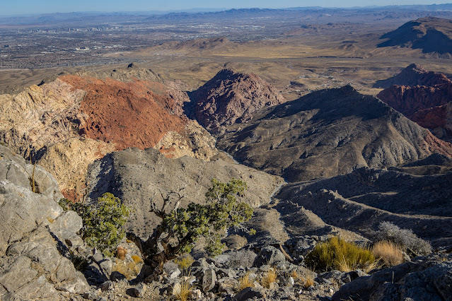
Below you can
see the Red Rock Park landscape, you can identify the trailhead parking lot, Calico
Hills and Kraft Mountain with their red and white color look very small from
here.
To the
southeast you can see Calico Basin and farther away the Las Vegas Valley urban
area and on a day with good visibility you can clearly see the Las Vegas strip
hotels.

On the other
side you can see above you the tall mountains of La Madre Mountains Wilderness.

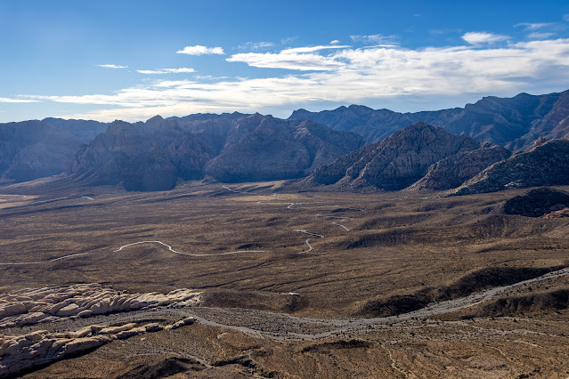
To the west on
the other side of the Red Rock large open valley, you can see the series of red
and white sandstone mountains in Rainbow Mountain Wilderness.

What an amazing
view all around you.
Once you rested
you need to hike down the same way you hiked up.
Take it slow on
your way down.
Overall, this
will be a challenging 4.6-mile-long hike with a total of 2,000 feet elevation
gain.
Additional Pictures:


Comments
Post a Comment